Compare the Addresses you Entered with the Mapped Addresses
Compare the Addresses you Entered with the Mapped Addresses
When you enter a list of addresses, you are entering the information as a text string.
After you have entered this string of text, we need to validate the addresses and get their physical location (latitude/longitude coordinates).
This process is called geo-coding. We use these coordinates to put a marker on the map and return a revised address to the list. From time to time, the text we return to the address list changes a little. This can be due to a zipcode change in the area, or various other reasons.
For your convenience, we have added the original text, underneath the geo-coded text so you can compare them and decide what to do with the original text. The original text only appears if it’s different than the geo-coded text, and only if you click to show it, as shown here:
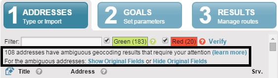
Ambiguous addresses
If you click Show Original Fields, this is what you will see:
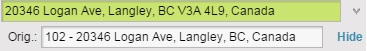
Original text
You have three options:
1) Click Hide and leave the geo-coded text as is.
2) Edit the geo-coded text and see if it is recognized properly.
3) Copy the Original text to the Title field, for reference.
For example, if we enter these two addresses:
a) 6595 197 St, Langley, BC V2Y 1G8, Canada – This detailed and accurate address will not change
b) 6, 7 – 8790 204 Street, Langley, BC – This ambiguous address will change to 8790 204 St, Langley, BC V1M 2Y5, Canada
These examples show that it is important to be as detailed and as accurate as possible, when entering addresses into our Route Planner. It will help us plan YOUR addresses better.
If we are unable to map the address you entered, we turn it to red and ask you to further verify it by adding more details or select between several alternatives. This is what you will see:
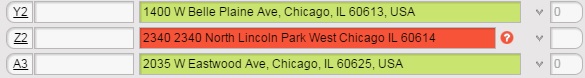
Red address
To correct this location, click Verify or edit the text inside the address field.