Ways to Measure Distance Between Two Addresses
February 29, 2024
Distance measurements are crucial to everyday life. The most practical example may be driving distance between two locations. If you are a professional driver or if you simply drive often, you probably need to know how far you are from a certain point and how long it will take you to get there, along with a mileage calculation.
There are several ways to measure distance between two addresses and it’s crucial to understand which method is best for your application. Read on to learn the various distance measuring methods so you can determine which to choose.
Euclidean Distance (As the Crow Flies)
This straightforward method measures the straight-line distance from one point to another. To find the distance, imagine your starting point and end point mapped out on a flat surface. Use a ruler or similar device to measure the distance between the two points. Then, translate this measurement to feet, miles, centimeters, etc., as needed.
Online tools will help you find an accurate distance based on the earth’s curvature. They use Haversine distance to calculate ”great circle” distance.
Driving Distance (Manhattan Distance)
Euclidean Distance also calculates the distance between two points, but it is not the most accurate technique for driving purposes. It does not account for routes to take to the freeway, navigating around busy streets, detours, and other factors. You must use a driving distance measurement to determine the distance between two cities.
Several GPS apps provide the driving distance from one destination to another. They will account for factors like traffic jams, detours, and construction sites to offer an estimation of your total travel and arrival time.
Chebysev Distance (Chessboard Distance)
Chebysev distance focuses on the theory of restricted movement and takes it to the next level. It is based on the concept of a chess game, which only allows certain pieces to move a square at a time. It considers the minimum amount of moves that will get you from one point to another based on the largest single movement you can make horizontally or vertically. This distance measurement is commonly used in robotics and game development.
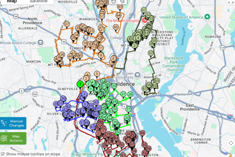
MyRouteOnline is the Ideal Driving Distance Planner
MyRouteOnline’s powerful route calculator is built on the Google Maps API. This means every route you plan leverages real-world road data, live traffic updates, and official restrictions that basic distance calculators simply don’t account for. Unlike tools that measure just straight-line or “as-the-crow-flies” distances, MyRouteOnline is designed to optimize complex, multi-stop routes—sequencing hundreds of addresses to minimize actual driving time, mileage, and fuel use. For example, a delivery company managing 100 stops across a city can save hours of driving and significantly reduce operational costs by having MyRouteOnline determine the most efficient route order, rather than relying on manual planning or simple linear measurements. This integration ensures your distance calculations aren’t just accurate—they’re optimized for the real world, helping your business boost efficiency and performance.
Different distance measurement tools serve different needs, Google Maps distances between one place to another is one that is very commonly used. But MyRouteOnline is the ideal tool for drivers who drive to multiple destinations each day. With Google Maps for example, you need to determine the order yourself, whereas MyRouteOnline Route Planner calculates the distances and creates the route in the smartest order.
There are many ways to measure distance, but there are a few solutions that will help you arrive at multiple destinations efficiently. Along with stress-free navigation, MyRouteOnline can route as many as 1000 destinations to help you save time, gas, and money which makes it the perfect option.