Optimize Your Routes with Precision: Lat Long Route Planning
June 24, 2026
Whether you are managing a global supply chain, dispatching a local fleet of delivery drivers, or coordinating field technicians across a wide service area, knowing when to rely on exact coordinates rather than street addresses can make the difference between a smooth operation and a costly mistake. Street names change, newly developed roads lack proper mapping, and rural locations often share confusingly similar addresses. In these cases, switching to latitude and longitude is the right call. Consider a marketing agency that installs advertisements on bus station shelters: many of those stops have no formal address, only a precise location on a map. Or think of an IT services company dispatching technicians to repair electricity poles in the field, where poles are identified by GPS coordinates rather than street numbers. In both cases, coordinate-based routing is not just helpful, it is essential.
By bypassing ambiguous street names and leveraging exact mathematical points, businesses and individuals can optimize routes, save fuel, and guarantee precise arrivals. But to fully harness this power, you need to understand how the system works from the ground up.
Unlocking the Cartographic Grid System Basics
To understand how modern routing software pinpoints a delivery van down to the square meter, we first need to look at the cartographic grid system basics.
For centuries, people have asked, “why do we use coordinate systems when we have landmarks and roads?” The answer is universality. A landmark can be destroyed, and a road can be renamed, but mathematical coordinates remain absolute.
At its core, the geographic coordinate system is an imaginary framework wrapped around the planet. By projecting horizontal and vertical lines on globe surfaces, geographers created a reliable way to intersect points and identify any location on Earth. Without this foundational grid, modern navigation, aviation, and logistics would be virtually impossible.
Equator, Prime Meridian, and Beyond
To master route planning, it helps to understand the invisible lines guiding your routing software. The grid relies heavily on measuring location using earths axis and its rotation to establish fixed reference points.
Here is how the globe is divided:
- The Equator: This horizontal line sits at 0 degrees latitude, splitting the globe into the Northern and Southern Hemispheres.
- The Prime Meridian: This vertical line sits at 0 degrees longitude, passing through Greenwich, England, and dividing the Earth into the Eastern and Western Hemispheres.
The equator and prime meridian significance cannot be overstated. Together, they act as the starting points (the zero-markers) for all global mapping. If you look at a standard hemispheres of the earth map, every single coordinate is measured by how far north or south it is from the equator, and how far east or west it is from the prime meridian.
It is also vital to understand parallels vs meridians:
- Parallels (Latitude): These are the horizontal rings that run parallel to the equator. Notable examples include the tropics of cancer and capricorn (located at approximately 23.5 degrees North and South, respectively), which mark the boundaries of the Earth’s tropical zone.
- Meridians (Longitude): These are the vertical lines that run from the North Pole to the South Pole. Unlike parallels, meridians converge at the poles. If you travel exactly 180 degrees east or west from the prime meridian, you will hit the international date line location, a crucial boundary for global shipping and aviation schedules.
Practical Applications: From the Field to the Highway
Today, this mathematical concept powers modern logistics. Instead of paper maps and physical landmarks, fleet managers use global position coordinates beamed from satellites.
When you input a destination into a routing algorithm, understanding the physical scale of the grid helps you grasp the precision involved. For instance, the distance between degrees of arc of latitude is relatively consistent at about 69 miles (111 kilometers). Minutes and seconds break that 69-mile distance down into increasingly precise fractions. By the time you get to the decimal points used in modern routing software, you are pinpointing a location down to a few inches! This level of granularity is exactly why coordinate-based routing outperforms traditional address-based routing.
Decoding the Numbers: How to Read GPS Coordinates
If a driver calls dispatch and asks, “what are the coordinates for the drop-off?”, you need to know how to interpret and relay the data. Learning how to read gps coordinates is a fundamental skill for anyone involved in logistics or route planning.
Coordinates are typically presented in two primary formats. Understanding the degrees minutes seconds to decimal degrees conversion is essential because different software platforms may prefer one format over the other.
- Degrees, Minutes, and Seconds (DMS)
- Degrees (°): The primary unit of measurement.
- Minutes (‘): There are 60 minutes in a degree.
- Seconds (“): There are 60 seconds in a minute.
- Decimal Degrees (DD)
- Positive numbers indicate North (latitude) or East (longitude).
- Negative numbers indicate South (latitude) or West (longitude).
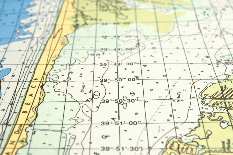
This is the traditional format. It looks like this: 40° 44′ 59″ N, 73° 59′ 11″ W.
This is the standard format used by most modern routing algorithms and computer databases. It looks like this: 40.7497, -73.9864.
Conversion Tip: To convert DMS to DD, you take the degrees, add the minutes divided by 60, and add the seconds divided by 3600. (e.g., 40 + (44/60) + (59/3600) = 40.7497). Fortunately, almost any modern logistics software will do this math for you automatically.
Leveraging Digital Tools for Lat Long Route Planning
You do not need to be a cartographer to implement this level of precision into your daily operations. A myriad of digital tools makes it incredibly easy.
If you have a specific destination but no exact address, a longitude and latitude lookup tool can bridge the gap. By typing a cross-street, a landmark, or simply dropping a pin on a latitude and longitude map, you can instantly extract the exact numerical coordinates.
Conversely, if a driver is lost in an area with poor signage, they can easily figure out “what are my coordinates” by opening almost any standard gps app on their smartphone. By relaying these numbers back to dispatch, the routing software can instantly recalculate the most efficient path to their next stop.
Actionable Tip: Finding Coordinates on Google Maps
Google Maps is one of the most accessible tools for quick coordinate gathering. Finding coordinates on google maps is a simple process that can save your delivery drivers hours of frustration:
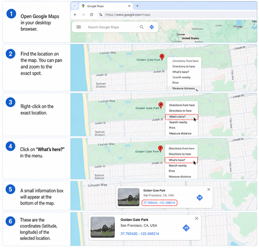
Find lat and long on Google Maps
- Open Google Maps on your desktop browser.
- Zoom in to the exact loading dock, driveway, or specific building entrance you want your driver to reach.
- Right-click on that exact spot.
- A drop-down menu will appear. The very top item will be the decimal degree coordinates (e.g., 34.0522, -118.2437).
- Left-click those numbers to automatically copy them to your clipboard.
- Paste these coordinates directly into your route planning software.
By doing this, your routing software will guide the driver directly to the loading dock door, rather than dropping them at the general front entrance of a massive warehouse complex.
Maximizing Routing Efficiency with Precise Data
Using coordinates instead of standard addresses fundamentally transforms how routing algorithms operate. Here is how relying on exact geographic data maximizes your operational efficiency:
- Eliminates Geocoding Errors: When you type “123 Main St” into an app, the software has to guess which “Main St” in which zip code you mean. Coordinates eliminate the “guessing” phase (known as geocoding), reducing the risk of a driver being sent to the wrong city.
- Optimizes Last-Mile Delivery: In rural areas, a mailbox might be a mile away from the actual house. By routing to the latitude and longitude of the house itself, you calculate accurate drive times and prevent drivers from wandering down dead-end dirt roads.
- Improves API Integrations: If you are building custom logistics software, feeding exact decimal degrees into your routing API processes data significantly faster and with fewer error outputs than feeding it clunky text-based addresses.
Conclusion
The shift from vague street addresses to absolute mathematical precision is a game-changer for routing efficiency. By understanding the basics of the geographic grid, from the significance of the equator to mastering how to read GPS data strings, you empower your team to navigate the world with total certainty.
Whether you are plotting a massive cross-country freight route or simply trying to optimize a dozen local deliveries, utilizing latitude and longitude ensures that your vehicles take the most direct, efficient, and accurate path possible. Stop relying on unpredictable street signs, start looking at the true coordinates, and watch your routing efficiency soar.
FAQ about Lat Long Route Planning
When should businesses use latitude and longitude instead of street addresses?
Businesses should use latitude and longitude when street addresses are unreliable or unavailable. Common examples include marketing agencies installing signage on bus station shelters that have no formal address, or IT companies dispatching technicians to GPS-identified electricity poles in the field. Coordinates are also essential in rural areas where addresses are ambiguous, on newly developed roads not yet mapped, and for pinpointing specific entry points like loading docks at large warehouse complexes.
What is the difference between DMS and decimal degrees formats?
DMS (Degrees, Minutes, Seconds) is the traditional format and looks like this: 40° 44′ 59″ N, 73° 59′ 11″ W. Decimal Degrees (DD) is the modern standard used by routing software and looks like this: 40.7497, -73.9864. To convert DMS to DD, take the degrees, add the minutes divided by 60, and add the seconds divided by 3600. Most modern logistics software performs this conversion automatically.
How do I find latitude and longitude coordinates in Google Maps?
Open Google Maps in a desktop browser and zoom in to the exact location you need. Right-click on that spot and a drop-down menu will appear with the decimal degree coordinates at the top (for example, 34.0522, -118.2437). Left-click those numbers to copy them to your clipboard, then paste them directly into your route planning software.
How precise are latitude and longitude coordinates for route planning?
The distance between degrees of latitude is approximately 69 miles (111 kilometers). Minutes and seconds break that distance into smaller fractions, and the decimal points used in modern routing software can pinpoint a location down to a few inches. This level of precision allows routing software to direct drivers to a specific loading dock entrance rather than a general building address.
How do coordinates improve routing efficiency compared to street addresses?
Coordinates eliminate geocoding errors that occur when routing software has to interpret ambiguous street addresses. They improve last-mile delivery accuracy in rural areas where a mailbox may be a mile from the actual property, reduce the risk of drivers being sent to the wrong location, and process faster in API integrations than text-based addresses.